Richard Smith, Joji Muramoto, Tim Hartz and Michael Cahn
UCCE Emeritus Farm Advisor, Extension Specialist, Emeritus, Extension Specialist and Irrigation and Water Resources Farm Advisor.
The winter of 2023 had the highest rainfall years in the last 25 years. The high rainfall resulted in flooding onto farmland along the main branch of the Salinas River in both January and March. The flood waters disrupted planting schedules as well as inundated established plantings resulting in a disruption to the beginning of the vegetable production season.
The river also deposited a layer of sediments in flooded fields (Photo 1). The sediments came from several sources: river sediments from as far away as San Luis Obispo County; sediments from side channels; and soil sediments scoured from upstream farms. Several growers and industry personnel have asked what is the composition of these sediments? In April after the flooding had subsided, we collected samples at river crossings from San Lucas to Salinas. The layer of sediment left by the flood waters tended to curled up as it dried out and were easy to collect. Any field soil was brushed from the bottom of the sediments and they were sent to the UC Davis Analytical Laboratory for analysis.
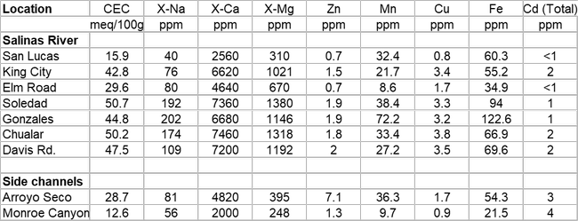
Tables 1 and 2 have analysis of the sediments collected. The data in the table is arranged with sites from south to north; the two side channels, Arroyo Seco and Monroe Canyon are listed separately. Monroe Canyon is the drainage that comes from the west side of Hwy 101 just south of the intersection of Hwy 101 and Central Avenue north of King City; it cuts through a large section of the Monterey shale formation that contains elevated levels of cadmium.
The San Lucas, Arroyo Seco and Monroe Canyon samples are coarser indicating that they were transported by rapid water movement, while the rest of the samples are dominated by silts and clays, indicating that they were transported by slower moving water. In general, there is a good correlation between the clay content of the sediments and nutrient and organic matter content. Higher nutrients in the silt and clay sediments include total nitrogen, calcium, magnesium, sulfate, zinc and iron. The sediments are generally fertile which may indicate that they are at least partially composed of soil eroded from farmed fields farther upstream. Sediments that are low in phosphorus likely originated from non-farmed or vineyard areas.
The elevated cadmium levels measured in sediments from the Arroyo Seco and Monroe Canyon indicate that these side channels carried sediments from the Monterey shale formation which has naturally high levels of cadmium into the Salinas River. Presumably these sediments originating in the Monterey shale formation are transported to areas further downstream by flood waters.
Photo 1. Sediments deposited in a field along the Salinas River
Table 1. Analysis of river sediment samples from locations from San Lucas to Salinas and two side channel locations.
Table 2. Analysis of river sediment samples from locations from San Lucas to Salinas and two side channel locations.


