The California Irrigation and Management Information System (CIMIS) operates and maintains more than 145 weather stations throughout California. The CIMIS program is funded by the California Department of Water Resources. Most stations are located on or near agricultural land, and provide measurements of reference evapotranspiration (ETo), which can be used to estimate how much water to apply to crops. Hourly, daily, and monthly averages of data are available through the CIMIS web site (http://www.cimis.water.ca.gov). The website includes an option to automatically email data from selected stations on a daily or weekly schedule. In addition to ET data, CIMIS stations record precipitation, relative humidity, air and soil temperature, solar radiation, wind speed, and dew point. Besides irrigation management, weather data can be used for plant disease forecasts, for calculating insect and crop degree-days, and for determining wind speeds during spray operations. Water management agencies use historical reference ET data to determine pumping demands, and to estimate future ground water supplies using mathematical computer simulation models.
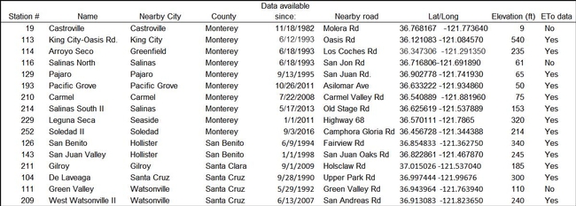
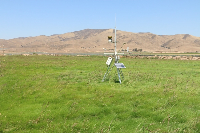
The Central Coast region currently has 16 active CIMIS stations (Table 1). Stations are located in Monterey, San Benito, Santa Cruz, Santa Clara counties. The newest station is #252 (Figure 1), located near Soledad CA on the east side of the Salinas Valley. CIMIS is a cooperative program, requiring collaboration between a local entity to provide land, maintain the site, and provide periodic servicing of the station. In some cases, stations are owned by the CIMIS program, but in many situations the weather stations are purchased through grant funding obtained by a local agency. Funding for station 252 was from a proposition 84 grant administered by the Coastal Conservation and Research Inc. The installation of the station was a partnership among Monterey County Resource Conservation District, UC Cooperative Extension (Monterey County), Dole Food Company Inc., CIMIS, Monterey Bay National Marine Sanctuary, and the Central Coast Wetlands Group (CCWG). Because CIMIS stations need to be sited on well-watered grass to provide accurate estimates of reference ET, funds from this grant were also used to establish 2-acres of grass surrounding the weather station and to install an underground sprinkler system.
Table 1. CIMIS stations located in the Central Coast region.
Figure 1. CIMIS station 252 located near Camphora-Gloria Rd, Soledad CA.
Even if a ranch has a private weather station, CIMIS data can still be useful. Many private weather stations are not instrumented to monitor ET or are not sited on a well-watered reference crop. Frequently private weather stations are located near a building, parking lot, or tree that can confound micro-climatic measurements. Over time instrumentation on weather stations can malfunction and record inaccurate data. The CIMIS system uses both an automated and manual quality assurance program to flag data that appear inaccurate or outside the normal range. CIMIS staff also service and check that the instruments are working properly. Additionally, CIMIS data are archived so that historical data can be accessed by users. CIMIS weather station data also contributes to Spatial CIMIS, a hybrid ET product that uses weather station and satellite data to provide reference ET estimates at approximately a 1-mile resolution. Spatial CIMIS reference ET data are also available through the CIMIS website.
During the past decade, significant progress has been made in adding new CIMIS weather stations or revitalizing old stations with improved site maintenance on the Central Coast. In addition to the Soledad station, Station 209 was established in West Watsonville, Station 211 was installed in Gilroy, and Station 210 was located in the Carmel Valley. Permanent grass was planted at station 129 in Pajaro and also at station 214 in South Salinas. Although progress has been made to increase the number and accuracy of CIMIS stations, weather stations are still lacking in some important Central Coast growing regions. Closer to the coast, the Castroville (#19) and North Salinas (#116) Stations are no longer reporting reference ET because the sites do not have sufficient grass cover to accurate measure ET. Also, the Green Valley road station (#111), which represents a warmer zone of the Pajaro valley no longer reports reference ET data due to insufficient grass cover at the site.
Having reliable long-term weather data from the main growing regions on the Central Coast is becoming more important for our region. As water demands continue to increase on the Central Coast, the agriculture community is under increased pressure to demonstrate efficient irrigation practices. Online irrigation scheduling tools such as CropManage and the Satellite Irrigation Management Support (SIMS), use CIMIS data to help growers quickly determine crop water needs. These tools can also help growers justify water needs of their crops. To comply with the Sustainable Groundwater Management Act (SGMA), water management agencies will need accurate reference ET data for developing ground water extraction plans. My hope is that through partnerships among local and state agencies, private land owners, and grower groups, we can add new or revitalize existing CIMIS stations so that all growing regions on the Central Coast have accurate weather data.

